Last month, J's parents invited us and his brother to meet them in Death Valley for a weekend trip over Easter weekend. Somehow Easter in Death Valley seemed appropriate, so we agreed. We packed up our best western gear and headed for the desert.
We had an uneventful flight from San Jose to Las Vegas, where we met J’s brother at the airport, and were picked up by his parents in a giant, black Jeep Wrangler, nicknamed Monique, which would be our road trip vehicle for the weekend. Our first stop was Whole Foods, to stock up on provisions, which for today’s modern family includes water, shrimp rolls, artisanal cheese and crackers, a mango smoothie, and chocolate-covered almonds -- only the essentials.
We then drove out to Death Valley, losing signal as soon as we left the Whole Foods parking lot, and relying on the downloaded maps I had remembered to save to my phone before we left home. We took NV-160 through Pahrump and Death Valley Junction, following the recommendations of this website the whole way. We had printed copies of the text of the website to refer to, which was good since no one in the car had any kind of signal for their phones. So while I could navigate us, we had no way to know what we wanted to go to! I won’t try to replicate all the information from that site, so check it out if you are thinking of going. Helpfully, it has not just recommendations about where to go, but how to get there, which, again, is important if you want to see some sights on your way in, but don’t yet have a park map or any idea of where you want to go.
Once inside the park, we took some crucial photos posing next to Monique so she wouldn’t feel left out of our group, observed the “no drones” warnings, and paid at the pay station. There were no maps available (and we would understand why later). And then we were off to see the sights!


Dante’s View: Turning left at the first turn past the pay station, we continued out to Dante’s View, which gives you a great view over the main area of the valley with the salt flats. According to the placards (always read the plaques), there is an underground river, the Amarosa, running along the valley, which dissolves soluble salts as it goes, and springs up along the valley, causing the salt deposits we could see from the viewpoint. Agua Amarosa means something like “bitter water” in Spanish. Dante’s View itself was named to go along with the general theme of the park (death) by the late-19th-century officials who created the park. The nearest ridge peak to the north is the site of the immortal words, “You will never find a more wretched hive of scum and villany.” (For an excellent overview of Star Wars filming locations in the park, check out this website.)


The viewpoint area was upgraded and completed in 2018, and it looked great, with a low stone wall and curving steel barrier on top. At either end of the overlook parking area, you can walk a trail along the ridge for additional views. The viewpoint is at about 5,500 feet of elevation, and you can really feel it as you hike up and down the ridges; but it’s also cooler than the valley below. In the distance is Telescope Peak, on the other side of the valley, at 11,000 feet, with snow on top. After hiking south along the ridge for a bit, we returned to the car and continued on.


Zabriskie Point: We passed by Twenty Mule Team Canyon and stopped at Zabriskie Point, surrounded by yellow mudstone and tilted layers of other stone. The history of this area is that there was once a lake here, where layers of silt and mud created the mudstone, which was later uplifted through seismic forces, and then eroded by rainstorms into the shapes seen today. Layers of darker stone are lava from ancient lava flows through the area. The landscape is beautiful and weird with almost no vegetation. The viewpoint itself has a paved, easy ramp up to the top, which is also paved in a giant flat circular area. The installation here also seemed new, although I didn’t see anything with a date on it. After our relatively quick stop here, we headed for the visitor’s center.

Furnace Creek Visitor’s Center: We arrived at the visitor’s center just minutes before closing, but managed to get a map and some water before being shooed out. To get a map, you have to present your paid ticket or park pass, which seems like a good system both to ensure people are paying, and also to give the rangers a chance to interact with you, answer questions, and advise you not to drive your sedan on unpaved roads, all while enjoying the air conditioning. A whiteboard posted inside indicated which roads and sights were closed, which in our case, was quite a few, including some we had thought to visit, so I’m glad we stopped by. I didn't see those closures indicated anywhere else, on maps or otherwise, although I’m sure they were on the NPS website somewhere - if you could get a signal.

The visitor’s center was a 1950s modernist pavilion with some kind of exhibit area that we didn’t get to see because they were closing, and a nice 3D topo map with lights you could illuminate to show you where different sights are located. The temperature was hovering around 105 degrees, but didn’t feel too hot.
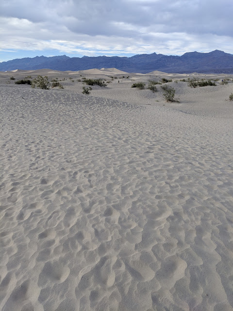
Mesquite Flat Sand Dunes: After our brief stop at the visitor’s center, we checked out the sand dunes, which are right next to our hotel, the Stovepipe Wells Hotel in Stovepipe Wells Village. The dunes are very impressive as they recede into the distance, with the mountains behind them, especially when the sun catches the top of them. Walking out to the highest dune is about a mile, though, so we didn’t do that. We wandered around for a bit, then continued on to the hotel, since it was already 6pm and we were pretty tired. We planned to go back to the dunes at night, since the weekend had a full moon. The dune area is another Star Wars filming location.
Stovepipe Wells Hotel: Our hotel room was spacious and had everything needed; the hotel has a pool, fire pit (...it was probably 90 degrees out, but it was on anyway) and very central location in the park. We had dinner at the restaurant, the highlight of which for me were the original Star Wars posters on the wall, including one Revenge of the Jedi poster.

We had breakfast in our room, then left around 10:15am and drove to Badwater Basin. If I can make a recommendation, get there earlier than 11; by 11 it was probably over 95 degrees and there is absolutely no shade. Badwater Basin is the lowest point (on land) in the western hemisphere, close to 300 feet below sea level, and it was quite amazing. The viewpoint has a walk out onto the salt flats, and where the salt is pitted, you can see that it is salt all the way down.


We skipped Natural Bridge, which our online guide had said was not as good of a hike as some of the later stops, and went to Devil’s Golf Course. For a place with such a silly-sounding name, it was pretty spectacular. The sharp, jagged salt formations continue on uninterruptedly in all directions for miles; there are very few places I have been with such a monotonous landscape. The viewpoint / parking area is near the middle of the valley, and very quiet (once all the cars turn off their engines).

Our next destination was Artist’s Drive, a one-way spur off the main drive, where you can see multicolored rock formations made of various minerals. We followed our online guide’s recommendation and stopped at the first area with a “DIP” sign, and hiked up an unnamed canyon. It turns out there was a second “DIP” sign shortly after, so it’s possible we went to a different one than he recommended, but we enjoyed it anyway, so if you want to try it yourself, stop at the first sign. The canyon was still shady at 12:30pm so it was a nice walk, with a scramble up a fairly vertical rock in the middle. The end was blocked by a rock fall, and we climbed on it but then turned around. There was no one else there, and the views back out toward the valley were lovely.


We continued down Artist’s Drive to Artist’s Palette, which is the mid-point stop where you can admire the colorful rock formations. By 1pm the heat and lack of cloud cover had started to make it oppressive to be outside. We had lunch in the back of the car, admiring the people who brought tents and chairs with them, so they could have a leisurely lunch. We didn’t hike around here but continued on after lunch. The rest of the drive has more interesting rock coloration but we didn’t stop.

Back on the main road, we next turned aside at Desolation Canyon, down a gravel road that ends in a roundabout far from the canyon mouth. As hot as it was, with no shade, we walked around the bend in the path to see if we could see the canyon mouth, and discovering that there was still no shade, we gave up. Too desolate.
Next we stopped at Golden Canyon to try again; by this time it was around 2pm, and in the high 90s. The parking area was nearly full, so there were many other families around, but J and I made it a couple hundred yards into the canyon and gave up; it was too hot. We didn’t even make it to where the canyon turns golden, but hid in the shade while everyone else continued along for a while. I was concerned about getting heatstroke and didn’t want to chance it.
Our final stop on this outing was the Timbisha Shoshone tribal office which has a small cafe serving tacos and shave ice. Let me clarify - pretty terrible shave ice. They were out of most of their flavors, weren’t sure what half the flavors were when we asked (I couldn’t remember what flavor is “mai tai” and had no internet with which to check). We ate ours anyway because it was cold and we were hot, but I don’t recommend it. The tacos looked disappointing as well, so we were glad we hadn’t relied on that for lunch.
At this point, J and I were wiped out and needed a break. We went back to the hotel and rested for a bit, then the in-laws rallied and went to Ubehebe Crater. After the 20-minute respite, I didn’t feel well enough to go with them, so I stayed and napped for another hour, then checked out the pool, which was unheated, therefore too cold for me, and not particularly nice either. A dust storm went by. Meanwhile, the in-laws thoroughly enjoyed Ubehebe Crater and walked the rim, climbed down to the crater, and were entertained by driving through the storm. It took them three hours, round trip, so if you’re wondering how long it takes to get there and back from Stovepipe Wells, budget three hours. After they returned, we hung out for a short while then went to dinner at the hotel. I ordered a locally-produced root beer that came in a weird boot-shaped glass. It was just ok.
After dinner, we went back to the Mesquite Flat Sand Dunes, by moonlight. We tried to see stars, but couldn’t see the Milky Way, and soon thereafter the moon came up so we couldn’t see them anymore. But with the full moon, we could see everything else. With my Pixel's "Night Sight" mode, I was able to get some amazing photographs of the moonrise. We walked back to the car without flashlights or headlamps, with the moon lighting our way.


We started the day with breakfast in our room, including some East Van Roasters chocolate from Vancouver as a special treat. By 10am we were out the door. We started with a quick photo op for me at the sand dunes, where everyone graciously allowed me a few minutes to take some photos with my Rey vest and lightsaber on the dunes. Then we were off toward Nevada and Las Vegas.
Our first stop was at Red Rock Canyon National Conservation Area, which is a one-way loop drive with many scenic viewpoints and places to stop. The area seemed very popular with climbers, and we saw a good number of them tackling the various cliff faces. We stopped at several viewpoints and took a short walk over to see some petroglyphs at one of the stop areas. One of the strangest sights were the red polka-dotted stones around the park, which looked like they had chicken pox; apparently these are iron-rich inclusions that collected in the stones and then show up as the stone weathers.


After the drive through Red Rock, it was on to Las Vegas, where we had lunch at a nice Thai restaurant on the outskirts of town. Then we dropped off brother-in-law at the airport, and had ourselves dropped off outside the Bellagio, with an hour or so to kill before our own flight. We watched the fountain (as over-the-top as one would expect), walked around the Bellagio, and walked through Caesar's Palace, while criticizing the lack of any authenticity whatsoever. Then we took a short 15-minute Lyft ride to the airport, and proceeded to wait through several delays until we could finally board our flight home.

Overall, I would certainly recommend a trip to Death Valley if you are going to be in the area, although I would suggest going earlier than April, starting your day as early in the day as possible, and and planning for two full days instead of a day and a half. The landscape is unearthly and beautiful. Pack all your own food, drive a large and comfortable vehicle, bring plenty of water and sun protection, and you might be able to hike more than one canyon! We had a good time even with just one canyon hike, though, and the Jeep was definitely a good call. Thanks, Monique, for keeping us cool and getting us where we needed to go.
Day 1 - Friday
We had an uneventful flight from San Jose to Las Vegas, where we met J’s brother at the airport, and were picked up by his parents in a giant, black Jeep Wrangler, nicknamed Monique, which would be our road trip vehicle for the weekend. Our first stop was Whole Foods, to stock up on provisions, which for today’s modern family includes water, shrimp rolls, artisanal cheese and crackers, a mango smoothie, and chocolate-covered almonds -- only the essentials.
We then drove out to Death Valley, losing signal as soon as we left the Whole Foods parking lot, and relying on the downloaded maps I had remembered to save to my phone before we left home. We took NV-160 through Pahrump and Death Valley Junction, following the recommendations of this website the whole way. We had printed copies of the text of the website to refer to, which was good since no one in the car had any kind of signal for their phones. So while I could navigate us, we had no way to know what we wanted to go to! I won’t try to replicate all the information from that site, so check it out if you are thinking of going. Helpfully, it has not just recommendations about where to go, but how to get there, which, again, is important if you want to see some sights on your way in, but don’t yet have a park map or any idea of where you want to go.
Once inside the park, we took some crucial photos posing next to Monique so she wouldn’t feel left out of our group, observed the “no drones” warnings, and paid at the pay station. There were no maps available (and we would understand why later). And then we were off to see the sights!


Dante’s View: Turning left at the first turn past the pay station, we continued out to Dante’s View, which gives you a great view over the main area of the valley with the salt flats. According to the placards (always read the plaques), there is an underground river, the Amarosa, running along the valley, which dissolves soluble salts as it goes, and springs up along the valley, causing the salt deposits we could see from the viewpoint. Agua Amarosa means something like “bitter water” in Spanish. Dante’s View itself was named to go along with the general theme of the park (death) by the late-19th-century officials who created the park. The nearest ridge peak to the north is the site of the immortal words, “You will never find a more wretched hive of scum and villany.” (For an excellent overview of Star Wars filming locations in the park, check out this website.)


The viewpoint area was upgraded and completed in 2018, and it looked great, with a low stone wall and curving steel barrier on top. At either end of the overlook parking area, you can walk a trail along the ridge for additional views. The viewpoint is at about 5,500 feet of elevation, and you can really feel it as you hike up and down the ridges; but it’s also cooler than the valley below. In the distance is Telescope Peak, on the other side of the valley, at 11,000 feet, with snow on top. After hiking south along the ridge for a bit, we returned to the car and continued on.


Zabriskie Point: We passed by Twenty Mule Team Canyon and stopped at Zabriskie Point, surrounded by yellow mudstone and tilted layers of other stone. The history of this area is that there was once a lake here, where layers of silt and mud created the mudstone, which was later uplifted through seismic forces, and then eroded by rainstorms into the shapes seen today. Layers of darker stone are lava from ancient lava flows through the area. The landscape is beautiful and weird with almost no vegetation. The viewpoint itself has a paved, easy ramp up to the top, which is also paved in a giant flat circular area. The installation here also seemed new, although I didn’t see anything with a date on it. After our relatively quick stop here, we headed for the visitor’s center.

Furnace Creek Visitor’s Center: We arrived at the visitor’s center just minutes before closing, but managed to get a map and some water before being shooed out. To get a map, you have to present your paid ticket or park pass, which seems like a good system both to ensure people are paying, and also to give the rangers a chance to interact with you, answer questions, and advise you not to drive your sedan on unpaved roads, all while enjoying the air conditioning. A whiteboard posted inside indicated which roads and sights were closed, which in our case, was quite a few, including some we had thought to visit, so I’m glad we stopped by. I didn't see those closures indicated anywhere else, on maps or otherwise, although I’m sure they were on the NPS website somewhere - if you could get a signal.

The visitor’s center was a 1950s modernist pavilion with some kind of exhibit area that we didn’t get to see because they were closing, and a nice 3D topo map with lights you could illuminate to show you where different sights are located. The temperature was hovering around 105 degrees, but didn’t feel too hot.
Mesquite Flat Sand Dunes: After our brief stop at the visitor’s center, we checked out the sand dunes, which are right next to our hotel, the Stovepipe Wells Hotel in Stovepipe Wells Village. The dunes are very impressive as they recede into the distance, with the mountains behind them, especially when the sun catches the top of them. Walking out to the highest dune is about a mile, though, so we didn’t do that. We wandered around for a bit, then continued on to the hotel, since it was already 6pm and we were pretty tired. We planned to go back to the dunes at night, since the weekend had a full moon. The dune area is another Star Wars filming location.

Stovepipe Wells Hotel: Our hotel room was spacious and had everything needed; the hotel has a pool, fire pit (...it was probably 90 degrees out, but it was on anyway) and very central location in the park. We had dinner at the restaurant, the highlight of which for me were the original Star Wars posters on the wall, including one Revenge of the Jedi poster.

Day 2 - Saturday
We had breakfast in our room, then left around 10:15am and drove to Badwater Basin. If I can make a recommendation, get there earlier than 11; by 11 it was probably over 95 degrees and there is absolutely no shade. Badwater Basin is the lowest point (on land) in the western hemisphere, close to 300 feet below sea level, and it was quite amazing. The viewpoint has a walk out onto the salt flats, and where the salt is pitted, you can see that it is salt all the way down.


We skipped Natural Bridge, which our online guide had said was not as good of a hike as some of the later stops, and went to Devil’s Golf Course. For a place with such a silly-sounding name, it was pretty spectacular. The sharp, jagged salt formations continue on uninterruptedly in all directions for miles; there are very few places I have been with such a monotonous landscape. The viewpoint / parking area is near the middle of the valley, and very quiet (once all the cars turn off their engines).

Our next destination was Artist’s Drive, a one-way spur off the main drive, where you can see multicolored rock formations made of various minerals. We followed our online guide’s recommendation and stopped at the first area with a “DIP” sign, and hiked up an unnamed canyon. It turns out there was a second “DIP” sign shortly after, so it’s possible we went to a different one than he recommended, but we enjoyed it anyway, so if you want to try it yourself, stop at the first sign. The canyon was still shady at 12:30pm so it was a nice walk, with a scramble up a fairly vertical rock in the middle. The end was blocked by a rock fall, and we climbed on it but then turned around. There was no one else there, and the views back out toward the valley were lovely.


We continued down Artist’s Drive to Artist’s Palette, which is the mid-point stop where you can admire the colorful rock formations. By 1pm the heat and lack of cloud cover had started to make it oppressive to be outside. We had lunch in the back of the car, admiring the people who brought tents and chairs with them, so they could have a leisurely lunch. We didn’t hike around here but continued on after lunch. The rest of the drive has more interesting rock coloration but we didn’t stop.

Back on the main road, we next turned aside at Desolation Canyon, down a gravel road that ends in a roundabout far from the canyon mouth. As hot as it was, with no shade, we walked around the bend in the path to see if we could see the canyon mouth, and discovering that there was still no shade, we gave up. Too desolate.
Next we stopped at Golden Canyon to try again; by this time it was around 2pm, and in the high 90s. The parking area was nearly full, so there were many other families around, but J and I made it a couple hundred yards into the canyon and gave up; it was too hot. We didn’t even make it to where the canyon turns golden, but hid in the shade while everyone else continued along for a while. I was concerned about getting heatstroke and didn’t want to chance it.
Our final stop on this outing was the Timbisha Shoshone tribal office which has a small cafe serving tacos and shave ice. Let me clarify - pretty terrible shave ice. They were out of most of their flavors, weren’t sure what half the flavors were when we asked (I couldn’t remember what flavor is “mai tai” and had no internet with which to check). We ate ours anyway because it was cold and we were hot, but I don’t recommend it. The tacos looked disappointing as well, so we were glad we hadn’t relied on that for lunch.
At this point, J and I were wiped out and needed a break. We went back to the hotel and rested for a bit, then the in-laws rallied and went to Ubehebe Crater. After the 20-minute respite, I didn’t feel well enough to go with them, so I stayed and napped for another hour, then checked out the pool, which was unheated, therefore too cold for me, and not particularly nice either. A dust storm went by. Meanwhile, the in-laws thoroughly enjoyed Ubehebe Crater and walked the rim, climbed down to the crater, and were entertained by driving through the storm. It took them three hours, round trip, so if you’re wondering how long it takes to get there and back from Stovepipe Wells, budget three hours. After they returned, we hung out for a short while then went to dinner at the hotel. I ordered a locally-produced root beer that came in a weird boot-shaped glass. It was just ok.
After dinner, we went back to the Mesquite Flat Sand Dunes, by moonlight. We tried to see stars, but couldn’t see the Milky Way, and soon thereafter the moon came up so we couldn’t see them anymore. But with the full moon, we could see everything else. With my Pixel's "Night Sight" mode, I was able to get some amazing photographs of the moonrise. We walked back to the car without flashlights or headlamps, with the moon lighting our way.


Day 3 - Sunday - Easter
We started the day with breakfast in our room, including some East Van Roasters chocolate from Vancouver as a special treat. By 10am we were out the door. We started with a quick photo op for me at the sand dunes, where everyone graciously allowed me a few minutes to take some photos with my Rey vest and lightsaber on the dunes. Then we were off toward Nevada and Las Vegas.
Our first stop was at Red Rock Canyon National Conservation Area, which is a one-way loop drive with many scenic viewpoints and places to stop. The area seemed very popular with climbers, and we saw a good number of them tackling the various cliff faces. We stopped at several viewpoints and took a short walk over to see some petroglyphs at one of the stop areas. One of the strangest sights were the red polka-dotted stones around the park, which looked like they had chicken pox; apparently these are iron-rich inclusions that collected in the stones and then show up as the stone weathers.


After the drive through Red Rock, it was on to Las Vegas, where we had lunch at a nice Thai restaurant on the outskirts of town. Then we dropped off brother-in-law at the airport, and had ourselves dropped off outside the Bellagio, with an hour or so to kill before our own flight. We watched the fountain (as over-the-top as one would expect), walked around the Bellagio, and walked through Caesar's Palace, while criticizing the lack of any authenticity whatsoever. Then we took a short 15-minute Lyft ride to the airport, and proceeded to wait through several delays until we could finally board our flight home.

Overall, I would certainly recommend a trip to Death Valley if you are going to be in the area, although I would suggest going earlier than April, starting your day as early in the day as possible, and and planning for two full days instead of a day and a half. The landscape is unearthly and beautiful. Pack all your own food, drive a large and comfortable vehicle, bring plenty of water and sun protection, and you might be able to hike more than one canyon! We had a good time even with just one canyon hike, though, and the Jeep was definitely a good call. Thanks, Monique, for keeping us cool and getting us where we needed to go.
Comments
Post a Comment